El Niño 2015-16 is officially done. Get set for La Niña.
Meteorologist/Science Writer
Friday, June 10, 2016, 2:51 PM - El Niño 2015-2016 is over, done and out, according to the latest update from NOAA's Climate Prediction Center. Now get set, because La Niña is on her way in.
After dominating climate and weather patterns since early 2015, and driving central Pacific Ocean temperatures to record levels, El Niño has finally dissipated.
"El Niño dissipated and ENSO-neutral conditions returned during over the past month," the June 9 NOAA Climate Prediction Center (CPC) report said. ENSO is an acronym for El Niño Southern Oscillation, which incorporates both the oceanic and atmospheric parts of the pattern.
The factors that indicated this transition?
After over a year of above average sea surface temperatures in the central and eastern equatorial Pacific Ocean, the oceanic part of ENSO, a band of near-average to slightly below-average sea surface temperatures spread across those regions in May.

Equatorial Pacific Ocean temperature anomalies, Dec 2015 to May 2016. Credit: NOAA Climate.gov
This has caused sea surface temperatures in the central region of the equatorial Pacific - the so-called Niño 3.4 region, which is the area forecasters focus on when tracking ENSO - to fall dramatically.

Weekly sea surface temperature anomalies from the Niño 3.4 region, comparing El Niño 2015-16 to 1997-98 and selected other events going back to 1990. These values show a greater variability than the longer-term monthly and ONI averages, but reveal the dramatic turn towards neutral ENSO conditions, and hint at the La Niña that is likely to come. Credit: S. Sutherland, with data from NOAA CPC
Also, the Southern Oscillation - the atmospheric half of ENSO - shifted from having lower pressure over the central Pacific, and higher pressure over western Australia, to its normal pattern, where pressure levels between those two locations are roughly the same.
|
|
|
"Collectively, these atmospheric and oceanic anomalies reflect a transition from El Niño to ENSO-neutral conditions," the report read.
What now?
While conditions in both the ocean and atmosphere now show that El Niño is over, it will likely be another month or two before NOAA's Oceanic Niño Index (ONI) catches up with that assessment.
ONI is a 3-month running average of sea surface temperature anomalies, used to not only track the progress of ENSO, but also to compare different events in the record. Forecasters and climatologists keeping tack of ENSO look at weekly and monthly records as well, to observe the short term fluctuations. It's ONI's longer-term average, however, that allows them to smooth out all the small-scale weather effects to see the big picture. Thus, even though forecasters have witnessed conditions return to neutral throughout the month of May, the latest ONI value includes the very warm conditions from March and April as well, and thus it sits at +1.1oC - well above the +0.5oC threshold for El Niño. The next ONI value will tally up April, May and June, and will very likely still be above that threshold. Whether the May, June, July tally will continue the trend will depend on exactly how quickly ocean and atmospheric conditions transition towards La Niña.
Once it does make that transition, though, it is looking more and more as though it will be a very fast one. With ENSO-neutral conditions across the Pacific now, forecasters are seeing the likely onset of a weak La Niña by July, or August at the latest, which will last through the fall and winter.
This closely resembles the timing of the transition between the 1997-98 super El Niño and the 1998-99 La Niña, however, the NOAA forecast doesn't indicate the pattern developing to the same strength as that event from 18 years ago.
Given the strength of the El Niño that the ocean and atmosphere are transitioning from, though, what the coming event may lack in strength, it could make up for in duration.
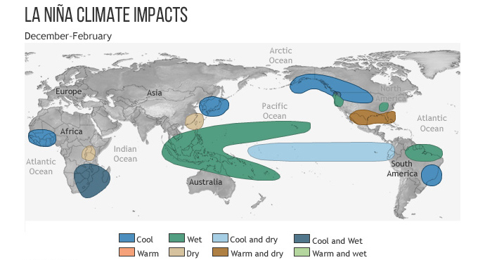
The global effects of La Niña during Northern Hemisphere winter. For Canada, it means cooler conditions across much of the southern Prairies and up the west coast, while wetter conditions are typically seen in southwestern B.C. and near the Great Lakes. Credit: NOAA Climate.gov
Sources: NOAA | Columbia University Earth Institute